Developing baseline nationwide biodiversity estimates and species distributions for >6000 plant species
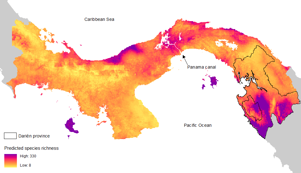
Figure: Species richness of plants across Panama, integrating various data sources and environmental and species trait information.
Estimating alpha-diversity, community composition, and species distributions provides an important baseline to understanding the effects of global change for such impacts as biodiversity loss and the erosion of ecosystem services. Here, we provide the most advanced estimate of nationwide plant biodiversity in Panama. To do so, we integrate data on species sightings (S), survey data (S), and a bias-adjustment kernel (BaK) based on environmental and species trait information (S2BaK species distribution model). To explore the distribution of species across Panama using S2BaK predictions click here.
The most common approach, using species sightings alone underestimated occurrences by ~4000% on average. Survey-only analyses performed less well on validation sites (AUC=0.81), as was not able to extrapolate to the >4500 species absent from the survey records. In contrast, the S2BaK substantially outperformed both, with higher AUC (AUC =0.97) and more than twice the explanatory power based on validation sites (deviance explained = 47%). Further, S2BaK had no obvious systematic underestimation, and could be applied to the broader set of species (>6000). This arguably provides the most advanced estimate of nationwide plant biodiversity in Panama.
For more information on the codebase, see https://github.com/PRISM-research/s2bak/.
Publications:
Leung, B., Hudgins, E. J., Potapova, A., and Ruiz‐Jaen, M. C. 2019. A new baseline for countrywide α‐diversity and species distributions: illustration using >6,000 plant species in Panama. Ecological Applications. https://doi.org/10.1002/eap.1866.
Land-based processes – modeling water and nutrient pollution across Panama
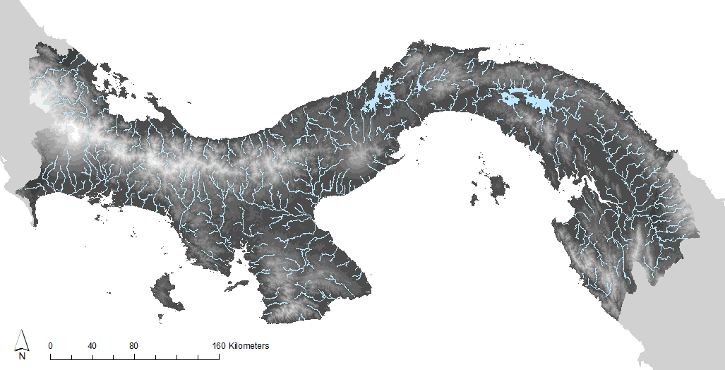
We create baseline layers to forecast water flow (and availability) and nutrient pollution using the SWAT model, calibrated for Panama, and validated using flow data. This will further be validated using nutrient data collected from the aquatic monitoring program. Thus far, the model predicts 80% of the variation in observed water flow. This will serve as the foundation to answer diverse questions, such as the effect of climate change and land-use on water availability and pollution. Additionally, we are building a statistical forecasting model that will be able to integrate this information on spatial patterning of rainfall to make better hydrological predictions given future scenarios.
Publications:
Varadarajan, S., Leung, B., Fábrega, J. 2022. Precipitation interpolation, autocorrelation, and predicting spatiotemporal variation in runoff in data sparse regions: Application to Panama. Journal of Hydrology: Regional Studies. https://doi.org/10.1016/j.ejrh.2022.101252
Scenario planning: Growth of Panama City in the coming decades
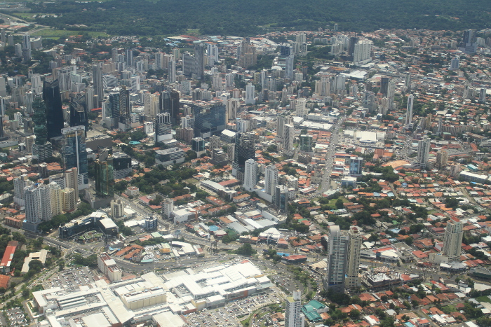
We partner with Ariel Espino to quantitatively project how urban development of Panama City could have nationwide effects on biological and physical elements of natural resources (i.e., an example or urban-rural “telecoupling”). Ariel is co-director of the team commissioned to plan the development of Panama City, and therefore the results of this project will be directly useful for discussions around sustainability.
The Panama Greater Metropolitan Area contains 50% of the country's population, and is anticipated to increase by a third by 2050. Relevant key issues about urban development futures include: densities at which new growth might occur; percent of future growth that will consist of informal development (squatter settlements); urban footprint encroachments on environmentally-sensitive areas; transportation inefficiencies that new growth might create, including increases in private car use; and pollution of air, soil and water through increases in solid waste and greenhouse gas emissions. Moreover, the effects of this mass of people, their needs, migration, and economic activities, will extend beyond Panama City's boundaries, which will thus have broader implications on biodiversity and physical effects (e.g., land-use, pollution, water use).
The work conducted in the urban growth project will have a parallel initiative in Montreal, Canada, through the McGill Sustainability Systems Initiatives, to compare and contrast, to look for generality, complementarity, and systematic differences between the different urban “ecosystems”.
Global shipping and resultant traffic through the Panama Canal
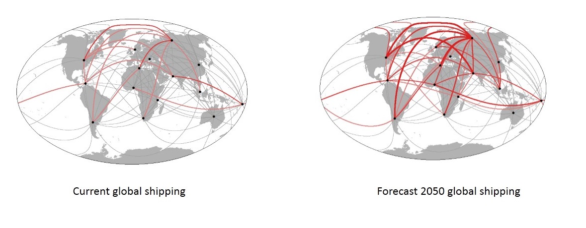
The Panama Canal is a major transit hub for trade between countries in Pacific and Atlantic regions, and also is an important component of the Panamanian economy.We have completed a global model of shipping traffic, linking them with macroeconomic predictors, and forecasting changes in shipping in the coming decades (r2=0.87). We have collated historical records of traffic through the Panama Canal, and by linking these together, we will be able to forecast change in traffic through the Canal, and the resulting effects on water usage and economics of Panama
Publications:
Sardain, A., Sardain, E., & Leung, B. 2019. Global forecasts of shipping traffic and biological invasions to 2050. Nature Sustainability. https://doi.org/10.1038/s41893-019-0245-y. Link to full paper.
Monitoring of river water quality in Panama
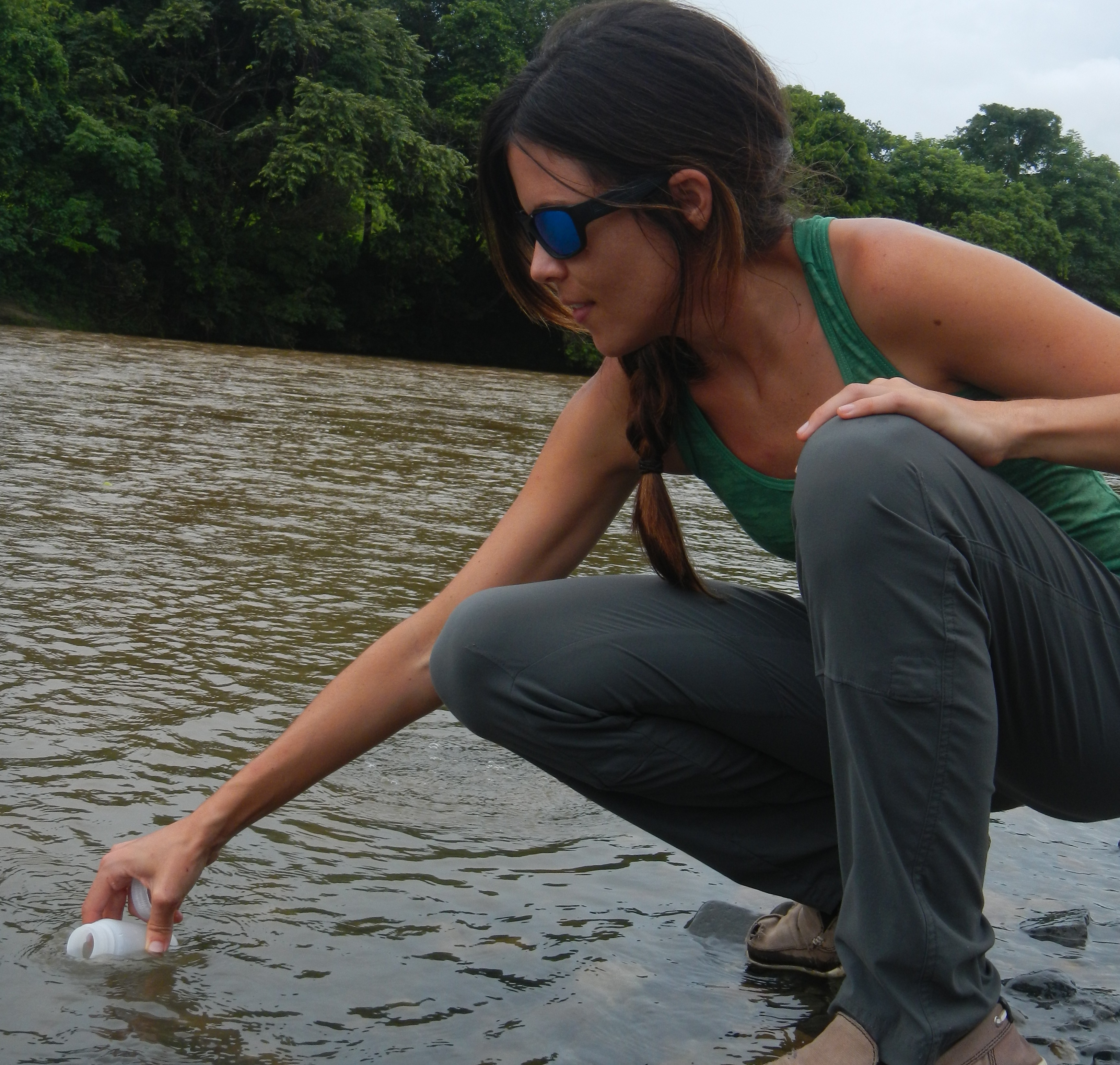
Human activities such as urbanization, deforestation, and industrial agriculture generate pollutants (eg nutrients, sediments, metals heavy) are transported to the coasts through rivers, altering the quality of water and the functioning of ecosystems. For instance, marine coastal environments, such as mangroves, coral reefs, and estuaries produce important benefits for human populations: their physical structures reduce coastal erosion and provide habitat for economically important species, and its tourist attractions generate considerable economic gains. To understand how aquatic and marine environments should change, we need baseline information on river parameters. We are conducting repeated sampling at 19 rivers across Panama to begin to construct that baseline information needed to measure future changes in the environment. Moreover, this monitoring will provide the data needed to validate scientific models, such as PRISM's land-based processes.
Modeling the importance of Panamanian forests to biological connectivity
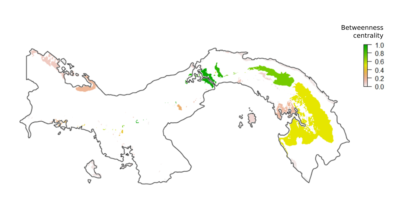
Figure: A map of ‘betweenness centrality’, a metric of individual forest patch importance to nation-wide forest connectivity, for the tropical moist forests of Panama. Values of 1 indicate high importance to nationwide forest connectivity, while values close to 0 indicate minimal importance. Blank areas represent forests that do not belong to the tropical moist forest type as well as other land uses in Panama.
Enhancing biological connectivity is increasingly becoming a preferred strategy for protecting biodiversity. Indeed, by ensuring species’ capacity for dispersal in the face of rapid anthropogenic change, connectivity management can be an effective conservation tool for a wide variety of species, ecosystem processes, spatial scales, and disturbance types. As part of PRISM, we seek to identify forest patches of greatest importance to Panamanian forest connectivity and ultimately propose priority areas for connectivity conservation in Panama. To do so, we model animal movement between forest patches using fine-scale maps of environmental variables and tree cover.
We are modelling forest biological connectivity at two spatial scales in Panama: at the national scale in collaboration with Omar Lopez at SENACYT, and at the regional scale for the District of Panama in partnership with the Panama City urban planner Ariel Espino. We will be continuing to work with Ariel in the next few months to incorporate connectivity considerations into the upcoming District of Panama territorial zoning proposal.
Spatial patterns of anthropogenic nitrogen inputs in Panama: Toward sustainable nitrogen management.
Excess of nutrients are a widespread environmental issue that modifies the dynamics of both freshwater and marine systems, with consequences for economic activity (e.g., fisheries, tourism), human health, and social well-being. The purpose of this research is to identify the sources and drivers of agricultural fertilizer inputs in Panama. This project will employ farmer surveys on fertilizer consumption, an agricultural census, and land use maps to quantify the nutrient inputs from various crops. Furthermore, the project will employ hydrological and spatial models to identify and map all nitrogen usage hotspots in Panama. The findings of this study will aid in the improvement of management strategies in Panama in order to provide opportunities for reduce their environmental impact of excess of nitrogen and provide important management practices in order to improve the efficient use of nitrogen fertilizers in Panama.
Spatial patterns and drivers of mangrove loss on Panama's central Caribbean coast: a baseline guide for management and conservation
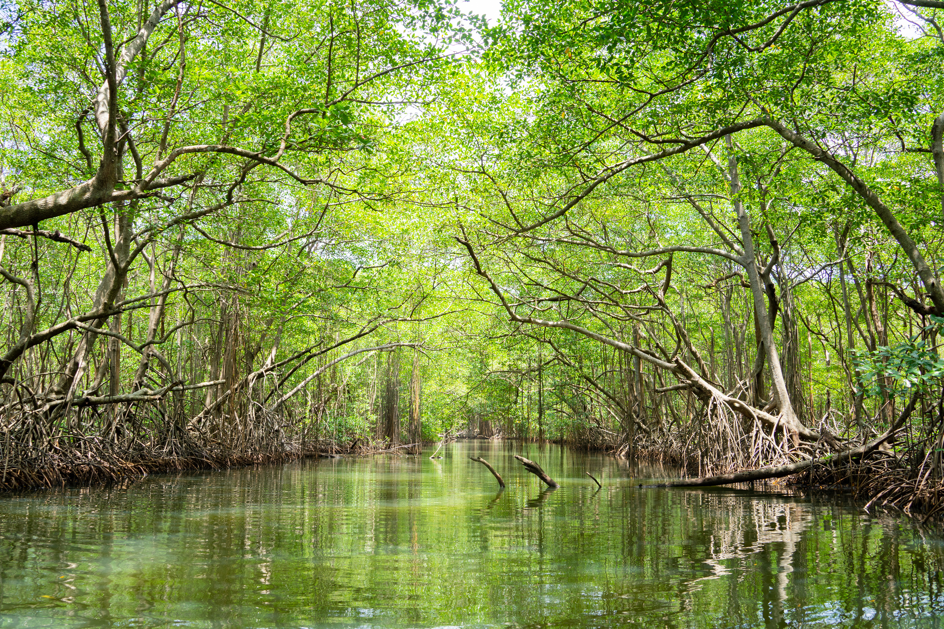
Mangroves are extremely important because they provide a wide variety of ecosystem services. Despite these benefits, these ecosystems are increasingly threatened, in part by human activities. This highlights the need to understand the drivers of mangrove loss to implement better conservation strategies in order to maintain the goods and services provided by these ecosystems. Using a variety of tools—including Landsat images, satellite environmental data, and spatial models—this research seeks to identify natural and anthropogenic drivers of changes in mangrove cover in the central Caribbean of Panama. Furthermore, the study intends to assess the vulnerability of mangrove ecosystems to each threat and investigate strategies for prioritizing conservation efforts. The findings of this research are expected to have implications for the management and conservation of mangrove ecosystems.
1 McGill University
2 Food and Agriculture Organization of the United Nations (FAO)
3 Smithsonian Tropical Research Institute (STRI)
4 Universidad Católica Santa María la Antigua (USMA)
5 Smithsonian Environmental Research Center (SERC)
6 La Secretaría Nacional de Ciencia tecnología e Innovación (SENACYT)
PRISM Small Grant Projects
Integrating a Data-centric Support System for Food Security and Human Health in Rural Panama
Javier S. Galan, Kristine G. Koski, & Marilyn E. Scott
Data relating to human health, demographics, and food security have been collected in two regions of Panama (Comarca Ngäbe-Bugle, Chiriquí Province; and Santiago, Veraguas Province) through various collaborations between McGill and local institutions such as SENACYT and INDICASAT. This project aims to compile and organize the existing data using standards for anonymity to deliver a curated database to be incorporated as a population survey layer of PRISM, while also training Panamanian students in database management and other related skills.
Estimating CO2 fluxes in a mangrove system
Dra. Nathalia Tejedor Flores, Dr. Reinhardt Pinzón, Ing. Ana Franco, & Ing. Jaime González
This project involves a detailed empirical study of CO2 and H2O fluxes in the mangroves of the Bay of Panama, which will be combined with knowledge of climatic variables to produce a computational model that can be used for forecasting of key processes such as carbon capture. It will also involve the training of students and researchers in both field and statistical methodology as well as outreach activities to spread awareness on the importance of the threatened mangrove ecosystem and the services it provides.
Mapping Indigenous Ethnobotanical Knowledge
Felipe Pérez Jvostov
This project will be carried out in collaboration with Ngöbe and Emberá communities and aims to bring indigenous perspectives on biodiversity and knowledge on their use of endemic flora together to produce an ethnobotanical encyclopedia that can integrate with the biodiversity layers already present in PRISM. Youth from the two indigenous communities will also be trained in the use of GPS and mapping tools in the process of compiling these new layers.
The Marine Botanical Layer: Putting Panama’s Seaweed Biodiversity and Social Network of Algal Collectors on the Map
Holly Cronin, Dipto Sarkar, Maycol Madrid, & Andrew Sellers
Data on algal biodiversity in Panama has historically been scant and difficult to access. This project aims to identify and bring together existing herbarium collection data in Panama to generate an interactive, accessible database and map layers pertaining to algal distributions and diversity, as well as to use spatial social network analysis to produce a knowledge map of algal researchers working in Panama.
Panama Coastal Aerial Photography Initiative
Steve Paton, Osvaldo Jordan
Panama’s shorelines and coastal ecosystems are facing threats ranging from sea level rise brought on by climate change to species invasion and resource exploitation, with 53% of mangrove area lost between 1969 and 2007. The Panama Coastal Aerial Photography Monitoring Initiative (PCAPMI) has carried out four aerial photography mission to document the state of the country’s mangroves since 2016. A fifth mission going from Panama City to the Costa Rica border on the Pacific coast, covering regions of special interest such as Coiba and surrounding islands in the Gulf of Chiriqui.
Verifying and Predicting Panamanian Forest Threats using Global Forest Watch Data
Proyecto Ecológico Azuero/Azuero Earth Project (AEP), Ruth Metzel
Threats such as fire and harvesting have led to the perception of the Azuero peninsula region as a high-risk region for investment in reforestation. This project aims to ground truth Global Forest Watch data about these threats and to deliver GIS layers documenting them, and to develop a predictive model for future risk of fire and harvest threats. These results and models will be made available as PRISM layers and also with shared with the Environmental Information System of Panama’s Ministry of the Environment.
Nutrient Monitoring in Panamanian River Discharge
Andrew J. Sellers, María Gabriela Castrellón
Monitoring and being able to forecast nutrient loading into rivers is a crucial aspect of understanding ecosystem processes and anthropogenic disturbance. This project, part of the water quality monitoring initiative, will implement a sampling procedure for nitrates, phosphates, and ammonia across sites where hydrological variables are already being monitored over both the wet and dry seasons. The resulting nutrient concentration data will also be used to calibrate and validate the PRISM countrywide hydrological model, using the Soil and Water Assessment Tool, as well as to build a comprehensive model of the Estibaná river in particular.